
While we slept – or perhaps I should say while we tried to sleep, for sleep evaded me for much of the night – the wind howled. When we woke, it was still – almost eerily so. Others camped around Corrour Bothy were, for the most part, yet to surface.
At home, I’m the breakfast bore; I’m the one who’ll take Shreddies or Cornflakes over Coco Pops any day. When camping, on the other hand, I crave something sweet: hot cross buns, chocolate chip brioche, pains au chocolat. While Laurence made his porridge outside, I scoffed a couple of chocolate brioches from the comfort of my toasty sleeping bag.

Stomachs sated, we packed our belongings away and headed down to the water’s edge. If you’re doing a multi-day hike – or even covering a moderate distance on a hot day, for that matter – you’ll need to refill your bottles at some point.
My advice? If you spot a stream, and the water is (a) running (i.e. not stagnant) and (b) clear, fill your bottle. You’ll inevitably find some areas are better than others for filling bottles, and there’s no point waiting until you’re out of water to start looking around for a suitable water source.
We bought a packet of Lifesystems Chlorine Water Purification Tablets a couple of years ago, thinking we might need them on the Tour du Mont Blanc. As it turned out, we never did – so after that trip, the packet returned to the camping box. Fortunately, these tablets have a very long expiry date on them and were still in date this summer. All we had to do was fill our water bottle, drop a tablet in, shake the bottle thoroughly and leave it for thirty minutes before drinking from it.*
*Each of our bottles was 1L. Don’t take the instructions for our water purifying tablets as gospel; always read the instructions on/in your packet before giving it a go.

We skirted the foot of Carn a’Mhaim (a Munro for another time), and then veered east through the Forest of Mar. Already, the temperature was climbing, and we were glad of the early start. Luibeg Burn, some three or so kilometres into the day and at this point more than a stream but not yet a river, was our only water crossing of the trip. Fortunately, the water was fairly shallow and – the odd slippery rock aside – it was straightforward to cross.

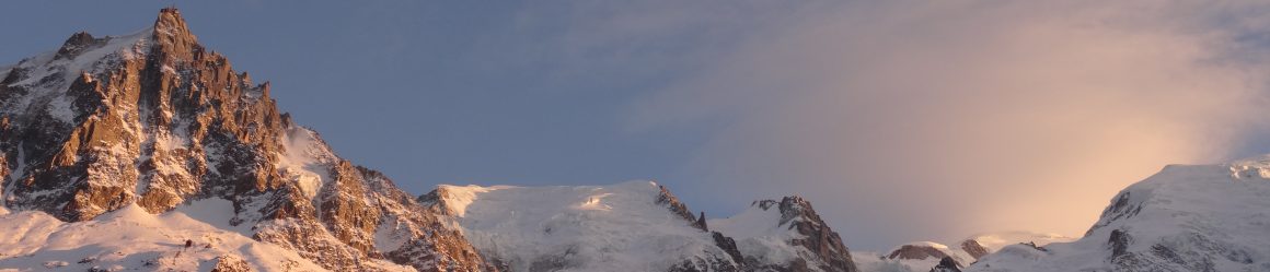
What followed was a pretty riverside path along the valley floor, and the photo above is one of my favourite photos from the trip. Near Derry Lodge, we plonked ourselves down on an overturned tree trunk for a mid-morning snack. At that point, we were feeling seriously glad we’d stopped at Corrour Bothy the previous night. Had we continued, we wouldn’t have reached Bob Scott’s Bothy (which is just downstream from Derry Lodge) until gone half ten at night.

Onwards and upwards: Beinn Bhreac beckoned. Keeping to the right of Derry Burn, we headed north towards Glen Derry. And this was where we came a bit unstuck. On a handful of occasions, we’ve found online what appears by all accounts to be a popular, well-trodden route – only for it not to be marked on our map. We knew what we wanted to do: follow the path through the woods for a couple of kilometres, and then veer up and to the east to get above the treeline.
Could we spot the path up through the trees? Nope. Non. Not for the life of us.
We knew we’d gone too far when the path took a sharp turn to the left. We retraced our footsteps, scanning the woodland to our left: ferns, trees, more ferns. And then, a little further back: two bikes, propped up against a tree. We’d seen them earlier, but had thought nothing of it; there were lots of mountain bikers in this area, and it wasn’t uncommon to see a few piled up beside paths. On the second sighting, however, a tiny, barely discernible path could be seen meandering up the hillside behind the bikes. Bingo!

We clambered up the hillside, finding the path boggy and slippery in places. I was intrigued by the frothy white substance on some of the plants (above), and some post-trip Googling revealed it’s commonly known as cuckoo spit. I’m not sure how the name came about, as there’s no link to cuckoos, but for those interested the liquid is a by-product of sap-sucking insects known as froghoppers or spittlebugs. Although their ‘spit’ may look a wee bit gross, it doesn’t harm plants.

Looking at the clouds scudding across the sky in the photo above, you’d be forgiven for thinking it was perhaps a little cool that day. But it wasn’t: it was stonking hot – and with the trees behind us, we felt every degree of it. (We’d slather on sunblock only to sweat it off virtually straightaway, it was that hot.)
We stopped for lunch just short of the summit of Beinn Bhreac, and ended up having a nice chat (a theme of this trip!) with another walker who was heading back towards Derry Lodge. She’d summited all of the Munros in this area on previous trips, so had spent her weekend hiking through the glens and around the lochs. We hit the top of Beinn Bhreac (931m, and our first Munro of the day) around 13.15 and had clear views in all directions – a luxury after the fog up Cairn Toul the previous day.

From the summit of Beinn Bhreac, the route to our second Munro of the day, Beinn a’Chaorainn, looked easy-going. On the map, it did too: a fairly level route, with lots of little green icons denoting ‘bracken, heath or rough grassland’.
In reality, it was four or so kilometres of bog-hopping. Maybe the spidery lines denoting a few small springs and streams on the map should have alerted us to this, but they didn’t. So off we went, hopping from one spongey patch of ground to another and wishing we were as well-equipped for this as the toads we spotted.

A couple of hours of bog-dodging later, and I was feeling rather glad to have put Mòine Bhealaidh behind us. We didn’t reach the summit of Beinn a’ Chaorainn (1,083m, and the second Munro of the day) until 15.30 or so, and by that point the slog across the bog was catching up with us.

We took a path heading off the summit in a south-westerly direction, and it wasn’t long before we discovered why it was a fairly narrow track. It was steep, scree-lined and slippery – three things I really don’t like in a path, especially when I’m going downhill.

Once safely on the valley floor, we filled our bottles from a stream and weighed up our options. We’d originally planned to round the day off with Beinn Mheadhoin, and then loop back to Hutchison Bothy for the night. Our legs were tired, and time had run away with us. The fog up Cairn Toul the previous day had thrown our plans off-kilter, but fortunately there was still plenty of wiggle room in our route. Beinn Mheadhoin could wait until the morning; we’d head straight for Hutchison Bothy and call it a day.
When we arrived at Hutchison Bothy, a couple of large rucksacks were propped up against the wooden sleeping platform. As it’s a fairly small bothy, we decided to pitch up outside (which was perhaps just as well, since when we left the following morning those staying in the bothy hadn’t yet woken up).

KNOW BEFORE YOU GO
- Maps and guides | OS Explorer OL57 is all you need for this route.
- Distance | 24.9km/15.6 miles; 929m of elevation gain
- Bothies | Many bothies are maintained by the Mountain Bothies Association (MBA). If you’re planning to stay at, or camp beside, a bothy, familiarise yourself with the Bothy Code before you go.
- Misc.| Leave some wiggle room in your plans and be prepared to adjust your route if the weather takes a turn for the worse or you’re simply feeling a bit worn out.

Beautiful photos of Two Beinns and excellent description specially cuckoo spit. I really didn’t know it’s called cuckoo spit. Loved to read it 💗☺️🙂💗
LikeLiked by 1 person
Thanks! Nor did I until recently. I learn something new on every trip 🙂 Glad you enjoyed the post.
LikeLike
Yes absolutely ☺️💖💓💐💐🌹💗❣️❣️💕👌💝💝My pleasure. Stay happy and blessed forever ❤️❤️☺️
LikeLiked by 1 person
Interesting tip on drinking water from nature itself! I never dared to refill water bottles directly from the stream, as who knows what bacteria and other unknown substances could be in there? But purifying tablets is a genius idea, and it really saves the hassle of stocking up on bottled water at the convenience store prior to camping! Your hike to the two Beinns looks to be quite the adventure, but a fruitful one!
LikeLiked by 1 person
I’d likewise be wary of filling a bottle straight from a stream, so the purification tablets do give you peace of mind that any nasty microbes have been killed off. I’ve also seen a few people with bottles that are fitted with a filter so you don’t need tablets, which is handy if you don’t want to have to wait for the tablets to work… and less handy if the filter were to break! Either way, being able to fill up with water along the way helps massively with keeping the weight of your rucksack manageable 🙂
LikeLiked by 1 person
The spittlebug holds a special place in our hearts and garden, as Spittle is our last name, a name I married into. Not a common last name here in the USA. Fortunately, our kids weren’t teased as badly as my husband was growing up.🙂 Love your posts!
LikeLiked by 1 person
I’ve not come across anyone with that surname on this side of the pond either, though I did know someone with the surname ‘Spittlehouse’. Good to hear the teasing has waned between generations! Thank you ☺️ Glad you’re enjoying reading them.
LikeLiked by 1 person